


GoechaLa Trek
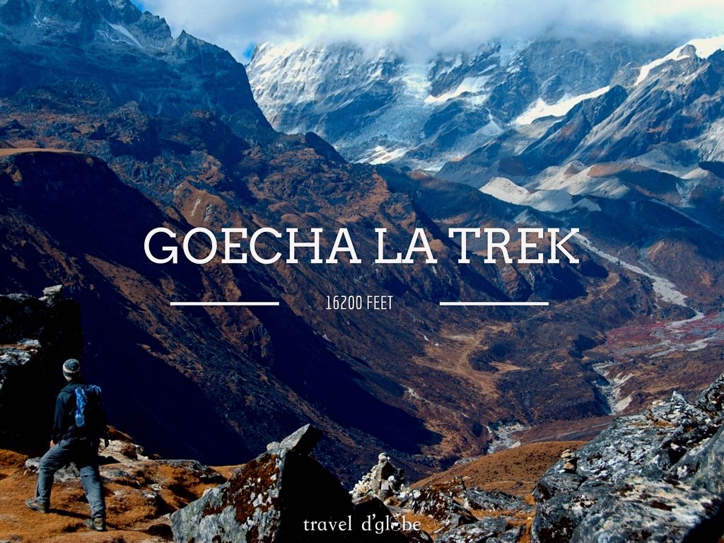
GoechaLa Trek
Things included in your Package
When and Why to take this tour
The terrain to Goechala is not easy and the trekking level is from moderate to difficult. The minimum age to conduct the trip is 13years and the maximum age depends on the physical fitness and health condition of the individual.
Tour Details
The southeast face of Mt. Kanchenjunga, the world’s third highest mountain, is viewable from the pass, which is also a base camp for those aspiring to scale the mountain. Trekking in Sikkim or the entire north east is totally different from trekking in the northern Himalayas. The people and culture are totally different .Nestled midst vibrant and colourful flora and fauna, this trek is also the way to the astounding Kanchenjunga National Park.
Itinerary / Tour Plan
Day 1: New Jalpaiguri (NJP) to Yuksom
Altitude: 5700 ft.
150 km drive, approx 8 hours
• Pick-up at 10am NJP railway station (Travel cost inclusive)
• Pass through Police Check Post at Melli. Foreigners need Inner Line Permit (ILP) – the driver will help get it. Procedure takes half-an-hour.
• From NJP to Melli (at the border of Sikkim and West Bengal)
• Lunch break at Jorthang
• Last ATM at Legship
• Base camp at Yuksom. Overnight in guest house.
Day 2: Yuksom to Sachen
Altitude: 7200 ft
8 kms trek, approx 6 hrs
• No shops on the trail. Erratic telecom network. Abundant water sources.
• Have packed lunch en route.
• Trail through dense forests, with frequent ascent and descent.
• After half-an-hour walk from Yuksom, you can see Tshokha
• Trail passes through three iron bridges (Gradual ascent till the first bridge, steep ascent for 20 min then gradual descent till second bridge and gradual ascent till third bridge. Walk for half an hour to the camp site.
• Be careful on trails as it stays busy with animals like yak and mules. Make way for the animals by sticking to the mountain side.
• Sachen campsite is in the forest, so accommodation in tents.
Day 3: Sachen to Tshokha via Bakhim
Altitude: Bakhim at 8600 ft and Tshokha at 9700 ft
7 kms trek, approx 5 hrs
• Pleasant walk till the last iron bridge (1 km from Sachen)
• Steep ascent till Bakhim – spot peaks like: Mt. Pandlm, Tenzinkhay
• Enjoy tea and refill water at Bakhim
• Bakhim to Tshokha – 2kms trek
• Trail lined with Rhododendron and Alpine berries
• Lunch at campsite
• Overnight in tents
Day 4: Tsokha to Dzongri via Phedang
Altitude: Phedang at 10500 ft and Dzongri at 12980 ft
9 kms trek, approx 7 hours
• The trail is mostly ascent – Tsokha to Phedang – 4.5 kms, 3 hrs and Phedang to Dzongri – 4.5 km, 3 hrs
• For the first hour, trail is rocky, for two hours it is wooden trail and once again rocky, zig-zag trail till camp site.
• Carry packed lunch and enough water as there are no sources of drinking water en route
Day 5: Rest day in Dzongari
Trek to Dzongari top at 13,675 ft, approx 1 hour
• Peaks spotted: Frey Peak, Kumbakarana, Rathong, Kabru South, Kabru North, Kabru Dome, Kangchenddzonga, Jupono, Pandim, Simro
• Instructions: Do not sleep, especially inside the tents, during the day. Go for small walks and explore the vicinity.
Day 6: Dzongari to Thansing via Kokcharang
Altitude: Kokcharang at 12,000ft, Thansing at 12900
10 kms trek, approx 6 hrs
• Dzongari to Kokcharang 8 kms trek, approx 4 hours
• Gradual walk through meadows and descend to reach Kokcharang
• Refill water at Kokcharang
• From Kokcharang, walk to the bridge towards Prekchu river. Rest and then ascend for 2 kms to reach Thansing
• Enjoy hot lunch at campsite
Day 7: Thansing to Lamuney
Altitude: 13650 ft
4 kms trek, approx 2 hours
• Morning call 8-9-10 (8am: tea, 9am: breakfast, 10am: Move for Lamuney)
• Easiest day of the trek – easy trail
• Enjoy hot lunch at camp site
• Trek further to Samiti Lake for 2kms
Day 8: Lamuney to Goechala via Samiti Lake back to Lamuney
Trek to Thansing (or Kokcharang, depending on the trekkers’ speed/weather)
Altitude: 16,000 ft
18 kms trek, 13 hours
• Longest and toughest day of the trek
• Call for Goechala 1am. Pack your backpack at night only, so when we return, we just have food and leave for lower campsite
• Lamuney to Samiti Lake easy walk for one hour
• Lamuney to View Point 1 (15100 ft – 5 kms – 3 hrs) Steep ascent for 2 hours
• View Point 1 to Goechala lake (15,700 ft – descent – 1.5 hours) to View Point 2 (16,000ft – steep ascent 40 mins)
• Move ahead of View Point 2, if weather allows.
• Descend to Lamuney for hot lunch
• Descent further to Thansing/Kokcharang
Peaks spotted: Kabru South, Kabru North, Kabru Dome, Kangchendzonga, Gocha Jupano, Pandim, Sinvo, Tenzingkhang
Day 9: Thansing/Kokcharang to Tsokha via Phedang
Altitude: Thansing 12,900 ft/ Kokcharang 12,000 ft to Tsokha 9700 ft
16 kms trek, approx 7 hours
• Start around 7am to reach by 3 pm Tsokha
• Carry packed lunch
• Kokcharang to Phedang (12 kms, approx 4 hrs) – gradual ascent and descent in the Rhododendron forest
• Phedang to Tsokha – descent for 5 kms
Day 10: Tsokha to Yuksom via Bakhim and Sachen
Altitude: 5670 ft.
15 km trek, approx 6 hours
• The trail is a complete descent on the same route as day 2 and 3
• Carry packed lunch
Day 11: Yuksom to NJP
150 km drive, approx 8 hours
• Leave Yuksom early morning to reach NJP by 5.00 pm
• Pack your backpack at night only, so you don’t have to be in rush before leaving for NJP
Things not included
Love for travel by our customers
Ratings and Reviews. Rated 4.9 out of 5 based on 9 reviews
About the place
Gangtok, the capital of Sikkim, is an absolutely spectacular town. Its proximity to Darjeeling makes it a strong attraction to the tourists visiting Sikkim. Situated at an altitude of 5200 ft. on a forested terrain, the town offers a marvelous sight of the snow-capped Himalayan mountains, including Mt. Kangchenjunga. The cool temperature and weather of Gangtok, along with the numerous monasteries in its vicinity offer a calm and serenity which is a bliss for travellers. But even through the calm, the town hustles like any other, like the M.G. Marg, a vehicle-free stretch, housing the local shops, restaurants featuring delicious cuisines, and hotels offering a splendid view of the Himalayan skyline.
Promise from Team TDG
Not sure? Get all details of this tour
Frequently Asked Questions
Disclaimer
travel d’globe has created itinerary for its travellers and is responsible for the travellers who booked it from www.traveldglobe.com only. Based upon the weather conditions, www.traveldglobe.com reserves all right to change this itinerary.
Did you find what you were looking for?
